Jaka is a remote valley in Malistan district of Ghazni province located on the south-eastern face of Hindukush mountains in Afghanistan. The valley is home to 520 families with farming as their main source of income. The main source of water for irrigation in Jaka is surface water from snowmelt from the Hindukush mountains. However, in the recent decade, people’s lives are significantly impacted by climate change as they face frequent droughts, increase in seasonality of surface water, decrease in harvests, decline in groundwater levels, heavy rains and flash floods.
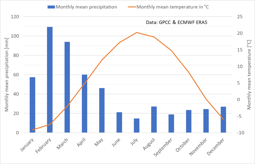
The valley receives sufficient precipitation of about 520 mm/ year but due to the lack of infrastructure and steep valley slopes, the water leaves the basin very quickly. Absence of water storage infrastructure also leaves the people very vulnerable to floods during the Indian monsoon season and early spring snowmelt and rainfalls.
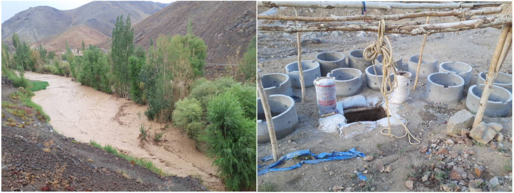
Climate change has induced enormous food insecurity in this valley as more and more fertile land cannot be farmed due to the water shortage. This forces the younger generation of the valley to migrate to large cities such as Kabul and even to foreign countries to earn a living for their families. According to locals, more than 100 people left Jaka for Europe alone. Children in particular are spending hours to walk long distance to fetch water for their family, because springs and wells nearby their homes are increasingly drying out. The villagers have built new wells increasing groundwater discharge.
Objectives of the adaptation project
To tackle this growing problem, Darya has initiated an adaptation program to address the key water availability and flood prevention issues in the valley by implementing low-weirs and trenching measures.
The cascades of low-weirs and trenches address the following objectives:
- To harvest rain and snowmelt water and reduce surface runoff which can otherwise lead to flash floods in the valley
- To direct surface water flow path into sub-surface and with that increase groundwater recharge and reduce evaporation losses
- To improve soil moisture and create pasture land for livestock in the valley
- Cash for work activity for short term job creation
- To transfer knowledge and experience from professional water and soil management experts to the locals who can then make use of them for further sites
The above objectives not only improve water availability in the valley but can also improve pasture land and create new agricultural land. The knowledge transfer to the locals helps the people to implement the measures in other potential sites in the area.
In search of a suitable adaptation site
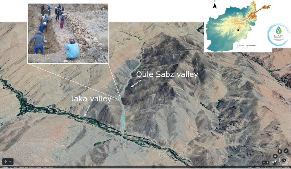
Jaka valley offers limited space for implementing any measure for flood prevention and groundwater recharge. However, there are several dry valleys that conflunces to Jaka and supplies water to the valley. The largest valley that drains to Jaka valley is called Qule Sabz valley with a total catchment area of about 8.2 km2 offers the best opportunity for implementing a low-weir and trenching technology. The Qule Sabz valley is 3.1 km long with average slope of 6%.
The Qule Sabz valley is largely dry and not farmed and thus implementing any measure there is not adversely affecting anybody. The only infrastructure in the project site is a connecting road which is located at elevated area of the valley and is not impacted by the measures.

How does low-weir and trenching cascade work?
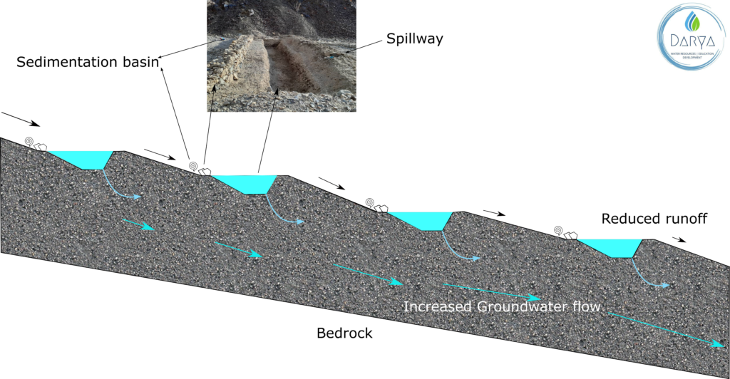
The cascades of low-weirs and trenches are designed to capture snowmelt and rain water during monsoon season and early spring months. Low-weir does two important functions. First, it stores water in its upstream and therefore increases the pressure of water and surface water infiltration into the sub-surface. Secondly, it functions as sedimentation basin which captures sediments carried out by water as it slows down the runoff velocity at its upstream. This paves the way for clean water to flow slowly into the trench and prevent premature sedimentation of the trenches.
Similarly, a trench captures surface runoff and increases water pressure which in turn induces more sub-surface flow and reduces downstream surface runoff as illustrated in Figure 4. Each low-weir and trench combination can store from 130 m3 to 200 m3 water depending on the available width in the Qule Sabz valley.
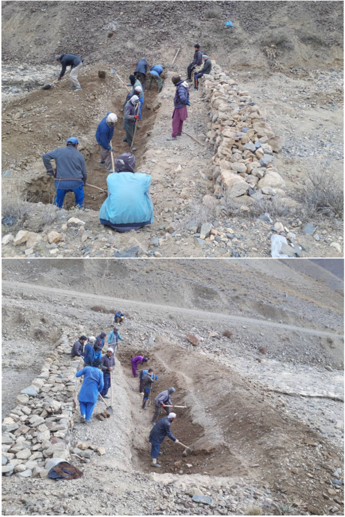
The project is implemented in four phases. In the first phase, the cascade of low-weirs and trenches are built 180 m apart, followed by those 90 m and 45 m apart in phase two and three respectively. By the end of phase three, around 60 low-weirs and trenches would be implemented in the Qule Sabz valley. Phase four mainly includes implementing the system in the seven major gullies of the Qule Sabz. The work on the first phase began on 8th November 2022 with daily workforce of 14 people from the locals.
Cash for work
Income opportunities in the valley are scarce. Darya will offer one-week employment contracts to the workers and pay 2000 Afghani. This should allow a high number of people to participate in the project and gain some income. When employing new workers, preference will be given to people from families who have not participated in the project so far. The photos on the right show the phase one of work during the erection of low-weirs and trenching cascades in Qule Sabz valley.
Monitoring of the adaptation outcomes
To assess the project outcomes both an on-site monitoring and a remote sensing approach will be employed. The on-site monitoring includes measuring the groundwater levels on a monthly basis and interviewing the locals regarding the flood preventative effect and agriculture and pasture conditions in Jaka and Qule Sabz valleys. The remote sensing analysis include using Planet lab and sentinel-2 satellite imageries for detecting the changes in water surface by short wave infrared composite (SWIR) and changes in vegetation health by Normalized Difference Vegetation Index (NDVI) for periods before and after implementation of the measures.